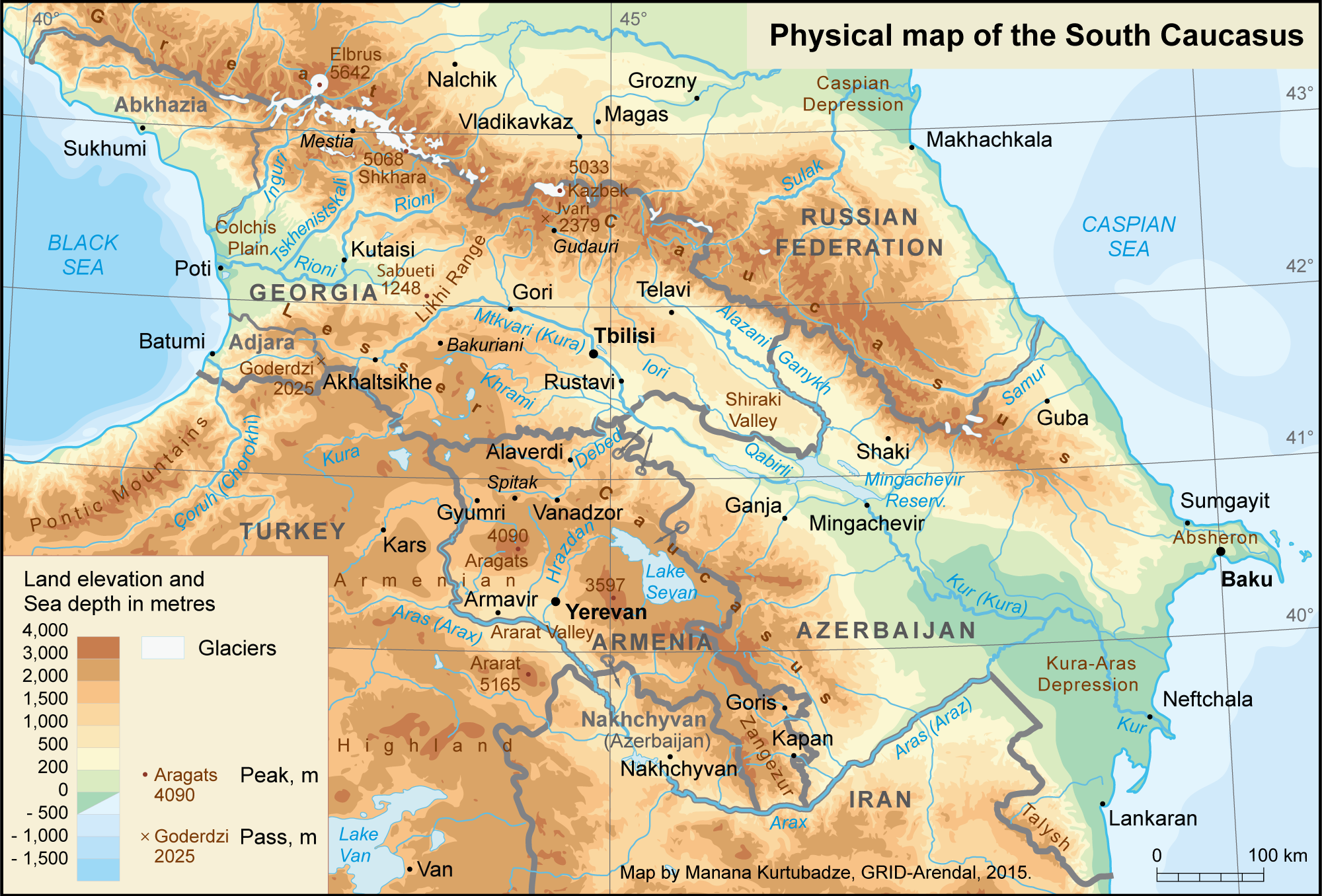
I will cover all south Caucasus countries in one article because Georgia has a relatively good de-jure borders. De-facto borders with "independent" Abkhazia and especially South Ossetia are a total mess, however. If Abkhazia has more or less cohesive borders for independent existence, South Ossetia is nothing more than a border gore around a few villages.
Azerbaijan and Armenia for the most part have decent borders. They have only one major border issue, that tangles both countries into a never-ending conflict.
That area of entanglement includes, Nagorno-Karabakh, Zangezur (Syunik province of Armenia) and Nakhichevan Autonomous Republic of Azerbaijan
First the good parts:
Georgian territory neatly covers the entire valley between caucasus gorge and the southern mountains of Armenia. Georgia can be split into two along the Likhi range, but that it unnecessary. Kura River, on which Tbilisi stands, does flow through Azerbaizan into Caspian Sea, but that alone it not a good enough reason to give it to Azeris.
Most of the Azerbaizan also has neat borders, it covers Kura River basin and has one single major space of flatlands, surrounded by mountains on pretty much all sides. There is part of Azerbaijan that extends north of Caucasus gorge, but land connection between it and the rest of Azerbaijan looks solid enough.
Armenia is the only country that is actually situated on mountains rather than in a valley surrounded by mountains, like the other two. Reasons for that could be that back in the days Azerbaijanis took all the best lands for themselves and pushed Armenians into mountains, but there could be other reasons as well.
The bad: Karabakh-Zangezur-Nakhichevan problem
Dispute over Nagorno-Karabakh recently ended with Azerbaijani military victory. Ethnically Armenian population fled, and Azerbaijan got control over the empty mountains.
That settles the old scores but does not solve any problems. Armenia now has to deal with refugees from Karabakh and Azerbaijan still does not have a direct land connection to its Nakhichevan exclave.
The situation between 1994 and 2020 only worked for Armenia. Armenia secured safety for its 150 thousand people in Karabakh at expense of making half million Azeris from surrounding areas refugees. Armenia was happy with that and only want recognition of independence for its Karabakh Republic. Azerbaijan was understandably not happy with that at all. Ultimately Russia, who wanted to play Armenia and Azerbaijan against each other, withhold formal recognition of Karabakh independence, but allowed Armenians to keep territory de-facto.
However the problem goes back to immediate aftermath of Russian Civil War, when the current official borders were drawn. Back then Communists made a Nakhichevan an exclave, separated from mainland Azerbaijan by Armenian territory. In contrast Armenian inhabitants in Karabakh were only given autonomy under the overall Azeri jurisdiction. Karabakh borders too were drawn completely landlocked inside Azerbaijan.
It is hard to discern any rationale for such borders beyond fostering future conflicts over the disputed area.
Potential Solutions
If they wished for a workable peace, they should have given south Zangezur to Azerbaijan to allow seamless connection between Nakhichevan and the rest of the county.
In contrast Karabakh should have been given to Armeania, however not with the Nagorno-Karabakh AO borders, but with different ones. They should have connected Karabakh to Armenia not via Lachin like they did after 2020 war, but rather via Kalbajar northern route.
Borders of Karabakh should have been tweaked to make it north heavy, so that there is a solid body of land, connecting it to Armenia. Northern Karabakh mountain gorge would serve as a natural barrier between Armenia and Azerbaijan. Stepanakert could have been good south-east most point of Armenia. Can even be extended to Martuni, but not to Hadrut.
In contrast Shusha, south Karabakh and south Zangezur should have been given to Azerbaijan to give them an equally solid access to Nakhichevan.
Even a straight lateral line from midpoint between Shusha and Stepanakert, that divides all areas of Karabakh, Syunik/Zangezur as well as areas between them, will make a decent border. Armenia gets all north of the line (but south of Artsakh de-facto northern border or mountain gorge it follows) and Azerbaijan all south of it. This line can be tweaked in both directions for some fine tuning.
Borders like that could have prevented all the bloodshed we have seen between these two countries. Theoretically they still can be achieved with enough good will from international community.
Conclusion
If nothing is done it will be likely that Azerbaijan will eventually invade and take Zangezur to make for direct land connection to not only Nakhichevan, but also Turkey. They have full Turkish backing to do this and even more. In contrast Armenia's old ally, Russia increasingly weak and negligent of this area.


No comments:
Post a Comment